Home → Bureaus & Programs → Bureau of Parks and Lands → Find Parks & Lands → Park Details
 Land for Maine's Future
 Maine Trail Finder
Description
Please check for access and COVID-19 updates by using this link to the Bureau's Safety page.
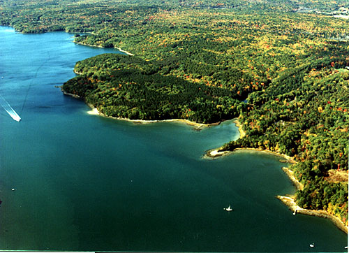
Dodge Point Public Land, located on the western shore of the Damariscotta River, encompasses 548 acres in the Town of Newcastle. The property boasts over 8,000 feet of frontage on the Damariscotta River with pocket sand and pebble beaches, vistas from the Rivers' shore, a freshwater pond, and stream-cut ravines in the interior uplands.
Download the Natural Heritage Hike for Dodge Point's Ravine Trail and Old Farm Road (PDF 2.24MB)
OR View the complete Natural Heritage Hikes listing. Natural Heritage Hikes are narratives that guide hikers through the rich ecological, geological, and cultural elements encountered on 25 of Maine's most popular hiking trails. These descriptions provide the hiker with the what, how, and why of the natural environments they are walking through.
If you are interested in learning about geology around the state check out the Maine Geological Survey Searchable Database.
Outdoor recreational activities abound here including hiking, cross-country skiing, skating, swimming and fishing. This well-managed forest bears the distinction of being named the State Of Maine's 1978 Tree Farm of the Year. Take the interpretive trail that starts at the Old Farm Road and make sure you explore the Shore Trail for the best views!
The Land for Maine's Future Board acquired the Dodge Point property on behalf of the State of Maine from the Edward W. Freeman Trust in March of 1989. In addition to the Land for Maine's Future Program, the Damariscotta River Association, now part of the Coastal Rivers Conservation Trust, and the Maine Coastal Program pooled funds to acquire the land for generations of visitors to enjoy.
Land for Maine's Future This property was acquired in part with funds from the Land for Maine's Future program. For more information about the LMF program and the places it has helped to protect, please visit the LMF webpage.
Activities
- Beaches
- Fishing
- Hiking (trails)
- Hunting
- Swimming
- Watchable wildlife
Rules
Consider lending a hand. Contact us if you would like to help with stewardship or maintenance work.
Trails
Dodge Point Public Land Maps:
Complete Guide & Map (871 KB/PDF 2 pages each 16x9-inches)
Map Only (493 KB/PDF 1 page 16x9-inches)
Visit the Dodge Point trail map on the Coastal Rivers Conservation Trust website.
Maine Trail Finder online map.
Services and Facilities
When to Visit
Open All Year