Skip Maine state header navigation
| There are eight lakes and four ponds within the waterway, and well over a hundred tributary brooks and streams flow into them and the river. These flowing waters provide for the needs of many kinds of plants and animals and present fascinating opportunities for exploration. The big lakes above the river provide an extensive storage capacity that helps control the river's level. From an aesthetic point of view, perhaps the most beautiful and distinctive quality of these lakes and ponds is their undisturbed, forested shoreline. Views of Mt. Katahdin from many of the lakes further enhance the beauty of the area. Allagash Lake is one of the most remote and beautiful lakes in the waterway. The lake covers 4,360 acres and spans three and one-half miles from its inlet to its outlet. It averages thirty-five feet deep; the deepest point is eighty-nine feet. The lake's waters are cold and well oxygenated, favoring cold-water fish. The north shore is shallow and sandy, inviting emergent aquatic plants as well as wading moose, deer, and great blue herons. Across the lake along the west shore are ledges of rough, colorful volcanic rock. To the east near the outlet, you will see an unusual shoreline edged by low glaciated ledges of Seboomook Slate. The slate forms the foundation and orientation for a number of small, sparsely-vegetated islands. These islands provide nesting opportunities for herring gulls and common terns. If you are fortunate, you may have the rare experience of seeing a Bonaparte's gull. 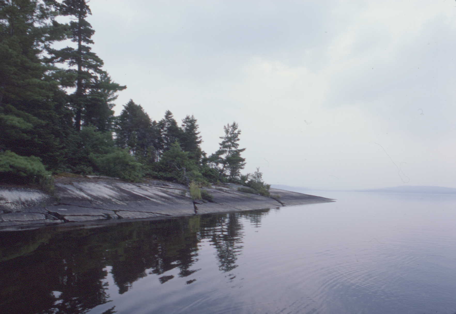 Glacial ledges, Allagash Lake Allagash Stream is the major flow of water into and out of Allagash Lake. Above the lake, in its upper reaches, the stream cuts through sand and gravel left at the front of the retreating glacier. As it approaches Allagash Lake, the stream slows and meanders over alluvial terraces and flood plains. In spring, white and longnose suckers come up the stream from the lake to spawn. It is also a time when tiny brook trout, called fry, are about. Sometimes you can spot wood turtles sunning on old logs. In summer, you may see spotted sandpipers searching along the shores, ducklings feeding, and moose and deer congregating where the stream enters Allagash Lake. Blue flag and the pink blossoms of sheep laurel color the stream's edge. From the lake, the stream flows about two and one half miles to Little Round Pond. Here the stream is youthful and vigorous, flowing over ledges and a boulder-strewn bed and between banks of swamp milkweed. Little Round Pond is a small, remote pond worthy of exploration. Northern white cedar dominates the northwest shoreline, while blossoms of northeastern rose and shrubby cinquefoil brighten the west shore in summer. At the outlet, the stream drops twenty feet over an outcrop of Seboomook Slate, forming Little Allagash Falls. Below the falls, the stream continues flowing over three ledges before leveling out. During the low water of summer, exposed gravel bars are crowded with large purple-fringed orchis, swamp candles, and tall meadow rue. As it approaches Chamberlain Lake, the stream slows, deepens, and widens. In the course of five miles from Allagash Lake, the stream has dropped ninety-three feet. 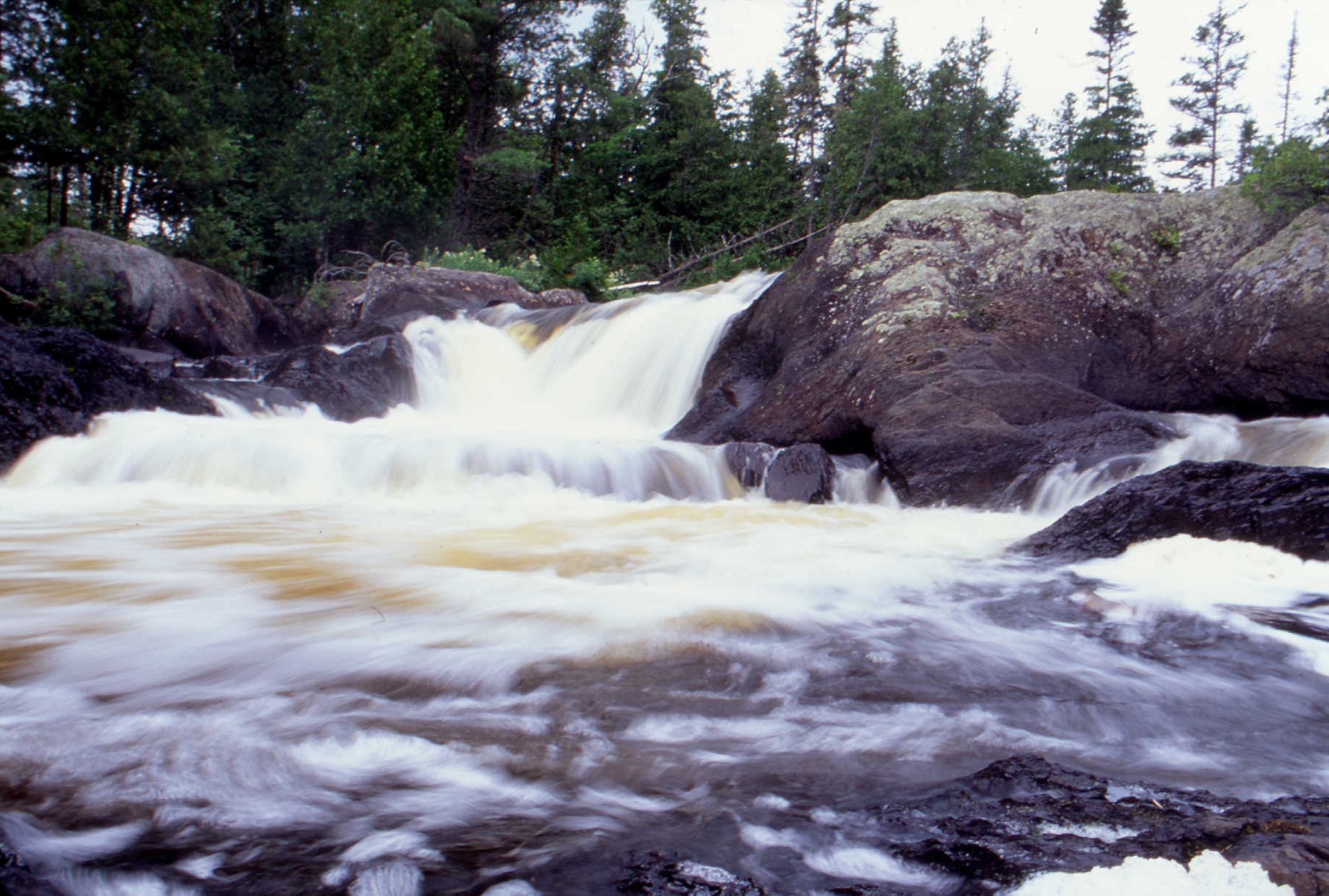 Little Allagash Falls Chamberlain Lake is the largest lake in the waterway. Sudden winds and dangerous waves call for caution on this and the other big lakes. Like most lakes in the waterway, Chamberlain is cold, clear, well oxygenated, and deep, favoring cold-water fish that attract ospreys, eagles, loons, and gulls. Herring gulls nest on a small rocky island near the mouth of Leadbetter Brook. Remember to stay well away from nesting birds as parents are easily disturbed and nestlings and eggs are vulnerable if parents leave the nest. One of the best places to see wildlife around the take is the marshy inlet cove where Allagash Stream enters. At its southern tip, Chamberlain Lake narrows into a small thoroughfare that leads into Round Pond and Telos Lake. In 1857 the naturalist Henry David Thoreau visited the stands of red pine that grow on the dry northeastern shore of Telos Lake. Eagle Lake, the second largest lake in the waterway, is 124 feet deep. Two major islands, Pillsbury and Farm, add to the lake's complex pattern. If you hike the scenic trail to the ledges on Pump Handle Peninsula, you will be rewarded by a spectacular view of Eagle Lake. You also will be able to look down on Russell Brook Beach, which makes a long, soft arc along the shore of Russell Cove. The sand, carried by Russell Brook to the lakeshore, forms a double-spit beach backed by a marshy lagoon. Several other interesting brooks flow into Eagle Lake. Smith Brook enters the lake in a large cove by a sandy point at the lake's southeast end. Wildlife is especially plentiful here and moose, deer, loons, and ospreys are common. Upstream, the brook has several channels and small backwaters, their surfaces broken by the pinkish outcrops of 400-million-year-old volcanic rock. Six miles north of Smith Brook, Soper Brook comes in on the east side of the lake. The brook's channel winds through a marshy cove and leads to a small waterfall. Snare Brook, which feeds into the smaller northern section of Eagle Lake, flows through a mile-long marsh. This marsh is worth checking in early morning or evening for wildlife. If you travel northward, you will leave Eagle Lake through a narrow channel and enter yet another Round Pond. Beyond, a thoroughfare fished by ospreys, eagles, and loons leads past Thoroughfare Brook to Churchill Lake. Churchill Lake is the third largest lake. A special scenic attraction is Churchill Ridge. It rises four hundred feet above the lake's northern shore and adds to the lake's beauty, especially in September and October when the spectacular fall colors of the hardwoods reflect from the water. Pleasant Stream flows into Churchill Lake on its northeastern shore. Canoeable for a short distance, the stream closes in quickly to a more secluded, marshy area. In fall, migrating Canada geese and greater yellow-legs have been observed here. If you paddle or pole up the narrow stretch of riffles above the marshy cove, you will find 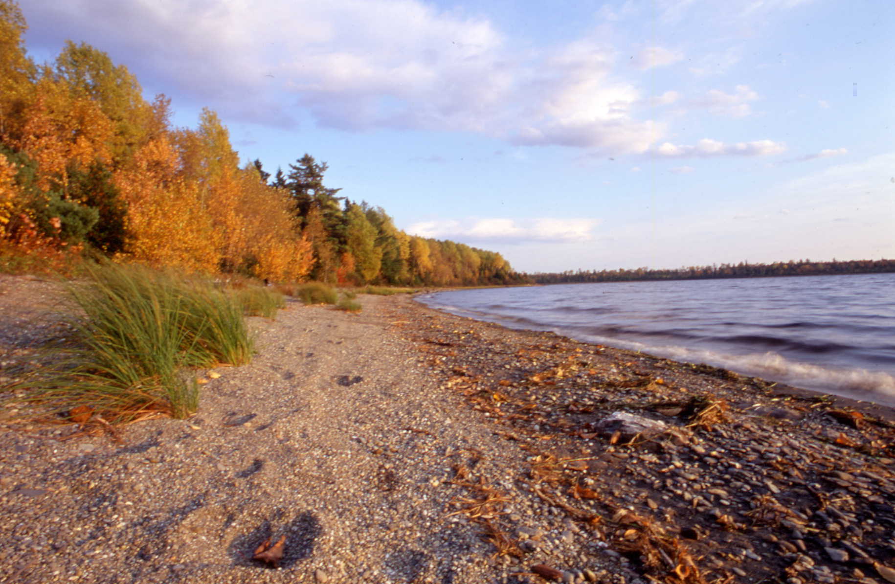 Moose tracks along the shore of Churchill Lake that the stream winds quietly through a bog forest dominated by tamarack. Down the northern shore of Churchill Lake, in its northwestern corner, the fall season usually reveals a beautiful spit of sandy beach leading into Heron Lake at the head of the Allagash River. |
Allagash River |
From the big lakes, the Allagash River flows north sixty-two miles and drops more than three hundred feet in elevation before reaching the St. John River. The most turbulent section is below Churchill Dam, where the river drops nine feet per mile in a wild four-mile stretch called Chase Rapids. It was along here in December of 1901, that hunters made one of the last authenticated sightings of Maine's caribou herd. Umsaskis Lake, at the base of Chase Rapids, is bordered on its western shore by steep ledges. Along this side, the mouth of Drake Brook offers the possibility of seeing a beaver. Across the lake, a ledge of weathered, metamorphosed sandstone juts out into the lake, and from it on a clear day you can see the top of Priestly Mountain two miles directly south. Priestly Lake sits in an isolated, irregular-shaped basin at the foot of this mountain. To get to Priestly Lake, follow a trail from the west shore of Umsaskis Lake. A narrow channel provides passage from Umsaskis to Long Lake. On the east shore Glazier Brook has deposited sand and silt to form a long, marshy delta. Several miles down the west shore, a sand beach protrudes into the lake and a short distance beyond is the mouth of Ross or Chemquassabamticook Stream. At the end of Long Lake, the river resumes its swifter flow. Spruce, fir, northern white cedar, and white birch, many festooned with long strands of beard lichen, crowd 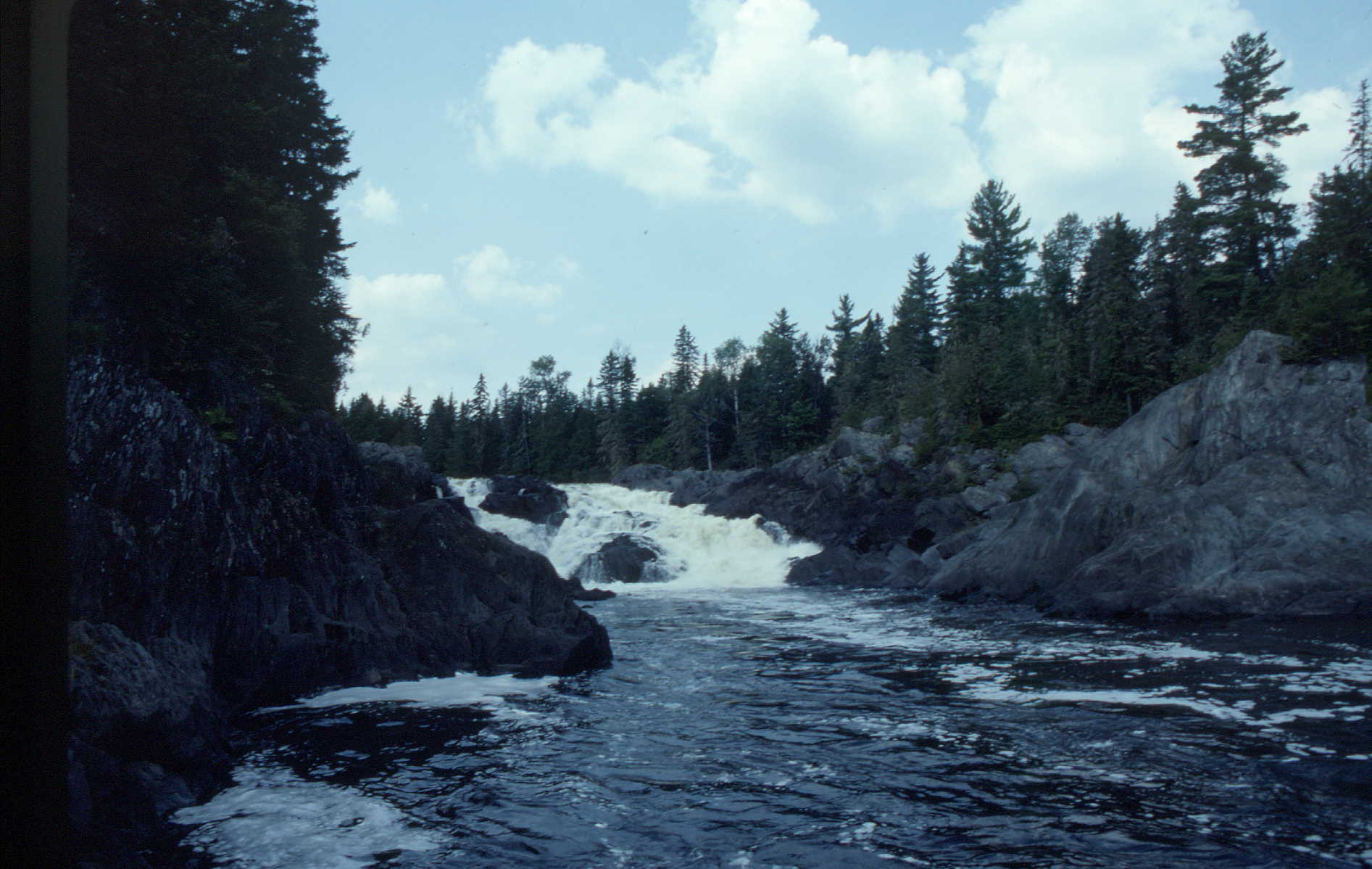 Allagash Falls the river's edge. Grassy pocket coves and thick clumps of alders indicate where small brooks enter the river. As you near Round Pond, the river breaks into three channels. The backwater near the north channel is a special place for observing birds and other animals. The river leaves the pond in a series of vigorous whitewater rapids, then after three miles, it turns to the southeast and soon passes an area where a tornado cleared a great swath in the forest on August 15, 1958. Farther along, large silver maples signal the mouth of Musquacook Stream, another major tributary. Bald eagles and ospreys are known to nest in the watershed of this stream and fish the nearby three-mile Musquacook Deadwater. Below the deadwater Five Fingers Brook enters, and the river continues to widen, gravel bars and low islands interrupting its flow. Above Allagash Falls, the river separates into several channels, and the surrounding land takes on the low, flat appearance of the northern riverine forest. At Allagash Falls the river tumbles thirty feet over a series of drops created by upturned, thin-leaved slate. At the foot of the falls, the rock is polished and contoured with many potholes. Remote and spectacularly beautiful, this waterfall is a registered critical area. Below the falls, large boulders, slate ledges, and low islands direct the river's channel. Silver maples, birches and balsam poplars line the shore. The waterway officially ends at the rapids of Twin Brook Ledges -- the last major outcrop of Seboomook Slate. The ledges are also registered as a critical area because of the rare plants that grow on them, namely New England violet and birds-eye-primrose. A few miles below, you will arrive at Allagash Village where the Allagash joins the St. John River. |
![]()
![]()
![]()