DACF Home → Bureaus & Programs → Maine Geological Survey → Hazards → Earthquakes → Recent Maine Earthquakes → 2-25-99 Earthquake
February 25, 1999 Earthquake in Central Maine
Weston Observatory reports that an earthquake occurred at 10:38:43 p.m. Eastern Standard Time on Thursday, February 25, 1999, southeast of Waterville, Maine. It was felt widely through the Augusta-Waterville area of central Maine. It was the largest earthquake in central Maine since December 28, 1988.
The following parameters have been calculated for the earthquake:
| Magnitude | 3.6 (Mn, local magnitude calculation after Nuttli, 1973) |
| Location | 44.489 North Latitude, 69.539 West Longitude |
| Depth | approx. 1 kilometer? (shallow) |
| This places the epicenter about a mile (2 kilometers) northwest of China, in the vicinity of the Winslow-China town line. | |
Further Information:
At the time of the event, Weston Observatory issued a preliminary determination of its location as about 2 miles east of Waterville, and its magnitude as 3.8. This determination of location and magnitude was widely reported in the news media, even to the unrealistic level of pinpointing the road intersection in Winslow indicated by the preliminary latitude-longitude coordinates. All three local television stations and statewide public radio covered the story on Friday the 26th. Articles ran on Saturday, February 27, in the Kennebec Journal (Augusta), Waterville Sentinel, and Bangor Daily News, among other newspapers.
Within a week, the location had been revised by Weston Observatory to about 2 miles farther southeast with a 3.6 magnitude. The initial determination by MIT placed the epicenter south-southwest of Waterville, about 6 miles west of the preliminary Weston location. On the Preliminary Determinations of Epicenters (PDE) earthquake list of the National Earthquake Information Center, based on calculations by the NEIC at the time of the event, this event is listed at 44.48 N, 69.52 W with magnitude 3.8.
Seismogram of the February 25, 1999 event recorded at the Waterville, Maine, seismic station. Note that the location and magnitude written on the diagram are the preliminary Weston values, which subsequently have been revised.
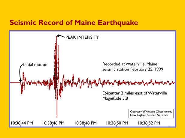
Seismic record of the February 25, 1999 earthquake in central Maine.
The event shows clearly on the Canadian Seismic Network Hourly plot for 3:00 (UT) February 26, 1999.
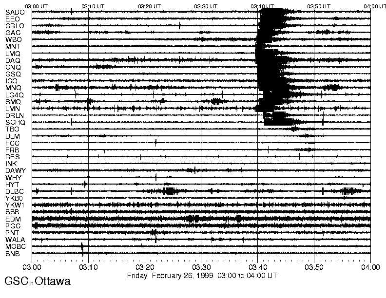
February 25, 1999 hourly seismic plot from the Canadian Seismic Network.
Press Release:
February 26, 1999 2:04 p.m.
Mainers Shake from Largest Earthquake in 10 Years
Internet On-line Survey Will Record the Event
AUGUSTA, Maine - State Geologist Robert Marvinney reports that the February 25 earthquake was Maine's largest earthquake within the last 10 years. The earthquake registered 3.8 on the Richter Scale and occurred at 10:38 p.m. EST about 2 miles east of Waterville. "The February 25 earthquake was the largest in 10 years and the third largest since modern instruments have been recording earthquakes in Maine," said Marvinney.
The Department of Conservation's Maine Geological Survey has posted an on-line survey on their Internet site to record the event. Mainers who experienced yesterday's earthquake can tell their experience by filling out the "Earthquake Questionnaire" that was developed in cooperation with the US Geological Survey. Residents are asked about specific information such as the type of soil and building construction, and the sorts of noises and movements that were felt during the quake. The site is located at the State of Maine home page, www.maine.gov under "Earthquake News and Questionnaire."
Residents without Internet access can call or write for the form. Contact the Maine Geological Survey Monday through Friday by phone at (207) 287-2801 or through mail:
Maine Geological Survey/Department of Conservation
93 State House Station
Augusta, ME 04333-0022
e-mail at mgs@maine.gov
"It is important to collect personal observations from many people as soon as possible in order to establish the size of the area affected, and the various types of effects people felt in different areas," remarked State Geologist Marvinney. "This information helps seismologists understand the way that seismic waves travel through the bedrock crust of Maine." Marvinney added that he felt the quake from his residence in Readfield and has already fill out the form describing his experience.
The Geological Survey asked residents to record their experience when a 5.1 earthquake centered in Quebec City shook residents throughout the state on November 5, 1997. "More than 200 people replied to the survey and that information has greatly enhanced our knowledge of the effects," replied Geologist Marvinney.
Modern seismographs have been monitoring Maine earthquakes only since the 1970s, and having similar first-hand reports for this earthquake will help to estimate the sizes and locations of historical earthquakes that occurred before modern equipment was available.
Reference:
Nuttli, Otto W., 1973: "The Mississippi Valley Earthquakes of 1811 and 1812; Intensities, Ground Motion, and Magnitudes," Bulletin of the Seismological Society of America, v. 63, No.1, p. 227-248.
Last updated on April 27, 2012