Home → Bureaus & Programs → Bureau of Parks and Lands → Find Parks & Lands → Park Details
 Land for Maine's Future
 Maine Birding Trail
 Maine Ice Age Trail
 Maine Trail Finder
Description
Please check for access and COVID-19 updates by using this link to the Bureau's Safety page.
Trailhead Coordinates: Lat 44.698689, Lon -67.158178
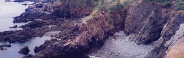
Those seeking a taste of wilderness along Maine's coast will enjoy exploring the Cutler Coast Public Lands, a 12,234-acre expanse of blueberry barrens, woodlands and peatlands with 4.5 miles of headlands (interspersed by pocket coves and cobble beaches) overlooking the Bay of Fundy. Hikers can enjoy 10 miles of trails, three remote tent sites and spectacular views from the property's steep cliffs-part of the dramatic "Bold Coast" that extends from Cutler to Lubec.
For a guided tour of the region's geologic highlights, see Hiking the Bold Coast, Cutler, ME. Learn about the geology of the area on the interactive Maine Geologic Facts and Localities map.
Land for Maine's Future This property was acquired in part with funds from the Land for Maine's Future program. For more information about the LMF program and the places it has helped to protect, please visit the LMF webpage.
Cool, damp and windy conditions along the coast tend to stunt tree growth and favor species that normally would occur in alpine and sub-alpine terrain such as Hookerâs iris, bird's eye primrose and baked appleberry. Birders have recorded nearly 200 species on or near the Cutler Coast. According to www.mainebirdingtrail.com, warblers, chickadees, golden-crowned kinglets and six species of owls frequent the woods, while seabirds and ravens nest along shoreline ledges. Offshore, from early summer to early fall, visitors may spot seals, porpoises and occasional humpback, finback, northern right and minke whales.
The lands north of Route 191 have several raised coastal peatlands (also known as bogs or heaths)-a plant community not usually found south of Canada. The bogs support an array of fascinating plants, including some sub-arctic and arctic species (such as Labrador tea) and carnivorous plants (such as pitcher plants and sundew) that draw nourishment from insects-rather than the acidic water and nutrient-poor soils.
The grassland "barrens," which were traditionally kept open by burning, contain species such as blue joint grass, flat-topped aster, alder and meadowsweet and support bobolinks and savannah sparrows. Due to the presence of bluejoint meadows and other exemplary natural communities such as huckleberry-crowberry bog and maritime spruce-fir-larch forest, Maine designated 5,216 acres of the property as an Ecological Reserve. The Reserve helps to maintain these representative ecosystems in their natural condition and allow for monitoring of ecological changes over time.
History
The igneous bedrock visible along the Cutler Coast (some of it in hexagonal columns of basalt) was deposited in the Silurian Age, roughly 420 million years ago, through a series of volcanic eruptions and intrusions of magma into existing rock. Much of the coastal land represents a plateau, sitting roughly 220 feet above sea level, that rebounded after the last glacial retreat (about 12,000 years ago).
An archaeological excavation in 1984 turned up stone tools and fire-cracked rocks, evidence that Native Americans used this coastline for centuries. European explorers first arrived around 1605, followed by settlers around 1785. The settlers, while few in number, harvested much of the region's valuable timber and erected a sawmill. Major fires in 1851 and 1854 created the extensive grassland "barrens" that dominate the property’s northern portion today. Following the fires, the mill was replaced by a dairy farm and-in 1881-a short-lived cheese factory. The stonewalls and cellar holes still evident on the land date back to this brief agrarian period.
Portions of the land were cut over for spruce/fir pulp by the Pejepscot Paper Company (using horses). Subsequent timber companies did extensive salvage harvesting in the 1980s following an outbreak of spruce budworm. A second introduced insect, the balsam wooly adelgid, is wreaking further damage on conifers.
The State of Maine acquired the coastal portion of the Cutler Coast Public Lands in 1989, thanks to The Conservation Fund and the Land for Maine's Future Program. In 1997, the preserve quintupled in size when The Conservation Fund/Richard King Mellon Foundation and Maine Coast Heritage Trust generously donated to the State a 9,485-acre tract of forests and grasslands on the north side of Route 191, and the Bureau of Parks and Lands purchased an additional 570 acres.
Activities
- ATV riding
- Birdwatching
- Camping
- Hiking (trails)
- Hunting
- Watchable wildlife
Rules
- Stay on the trail at all times to protect fragile ecosystems.
- Open fires are strictly prohibited. Cook only on self-contained stoves that produce no ash.
- Cut no live vegetation.
- Carry out all trash.
- Keep pets under control at all times and on a leash (no longer than 4 feet) at campsites.
- Camp only at the three designated sites by Fairy Head. Camping stays on public lands are limited to 14 days in any 45-day period.
- Although hunting is permitted, do not discharge weapons within 300 feet of any picnic area, camping area, parking area, posted trail or other developed area. Loaded firearms are not permitted at campsites or on hiking trails.
- ATVs (which are permitted on the lands north of Route 191) may only go on roads and trails posted as open.
- Bureau of Parks and Lands staff may take custody of any personal property left unattended for more than 3 days (unless advance written permission is given).
Consider lending a hand. Contact us if you would like to help with stewardship or maintenance work.
Trails
Natural Heritage Hike for Cutler Coast Public Reserved Lands - Black Point Loop. OR View the complete Natural Heritage Hikes listing.
Natural Heritage Hikes are narratives that guide hikers through the rich ecological, geological, and cultural elements encountered on 25 of Maine's most popular hiking trails. These descriptions provide the hiker with the what, how, and why of the natural environments they are walking through.
Visit the Cutler Coast Public Reserved Land trail map at Maine Trail Finder.
The coastal portion of the property has hiking trips from 3-10 miles. Wear sturdy footwear and take care near cliffs and on boardwalks, particularly in damp and slippery conditions. The estimated trail times listed below assume a leisurely pace in good conditions with brief stops.
Coastal Trail to Ocean (2.8-mile roundtrip, allow 2 hours) A forested path that runs through a cedar swamp and maritime spruce-fir forest before reaching a promontory overlooking the ocean. This is the easiest trail segment: the remainder is moderately difficult.
Black Point Brook Loop (5.5-mile roundtrip, allow 4-5 hours) Wooded trails and rocky cliffside hiking lead to a small cobble beach at Black Point Cove (accessible via a log ladder). The return route, via the Inland Trail, is somewhat rocky but over fairly gentle terrain.
Fairy Head Loop Trail (9.1-mile roundtrip, allow 6-7 hours)
This trail provides the most extensive shorefront hiking with 3.8 miles that skirt the shore. At Fairy Head, the trail turns inland through open meadows and forest, passing by a freshwater grass marsh and a large beaver pond.
On the forested northern portion of the property, across Rt. 191, there are 19.5 miles of shared-use roads and designated ATV trails, many of them maintained by the East Stream Trail Riders ATV Club. A portion of this system passes through the Ecological Reserve: please remain on the trail to protect the Reserve grasslands and fragile peatbog ecosystems.
Services and Facilities
Special Considerations
Cliff tops are often undercut and can be dangerous (particularly in wet conditions). Stay on the trail and supervise children closely.
The three permitted campsites are 4-5 miles from the parking lot. Carry in food, water and camp stoves (campfires are prohibited).
On Maine’s public lands, some timber harvesting is done to generate revenues for property stewardship. Potential harvest areas at Cutler lie north of Route 191 and are clearly signed if active.
When to Visit
The Cutler Coast lands are open year-round but take extra care in wet or icy conditions. The summer months offer the best likelihood of spotting whales offshore and birdwatching opportunities are excellent from spring through fall. Mosquitoes and black flies are thickest in late May through early July. Wild blueberries ripen in late July and early August.